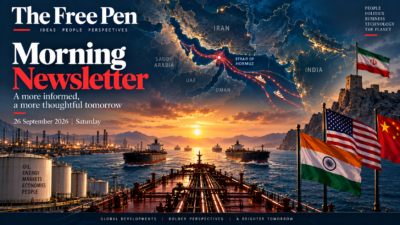
It can head towards the Strait of Hormuz, squeeze through the narrow waterway between Iran and Oman, and enter the Arabian Sea. From there, it can sail towards India, China, Japan or Europe.
But if Hormuz becomes unsafe, the problem is not simply that one stretch of sea has become dangerous.
The entire journey changes.
Ships may have to wait. Cargoes may have to be rerouted. Insurance becomes more expensive. Fuel consumption rises. More vessels are needed to carry the same amount of cargo because each voyage takes longer.
And eventually, something that happened thousands of kilometres away can show up in a familiar place: at a petrol pump, in an electricity bill, in the price of a manufactured product or in the cost of a container arriving at an Indian port.
This is the strange power of a maritime chokepoint.
The world’s oceans are enormous. But ships do not move randomly across them. Geography funnels enormous volumes of trade through a surprisingly small number of passages.
Some are natural straits. Others are man-made canals. Some are technically wide enough for ships to pass comfortably, but are strategically important because there is no equally convenient alternative.
Together, they form something like the world’s maritime plumbing.
And when one of those pipes gets blocked, the consequences can travel surprisingly far.
So, what exactly is a chokepoint?
A chokepoint is a narrow or strategically constrained passage through which a large amount of traffic must pass.
Think of a six-lane motorway suddenly narrowing to a single bridge.
The bridge does not need to carry every vehicle in the country to become important. It only needs to carry a sufficiently large share of traffic with sufficiently few alternatives.
That is what makes maritime chokepoints powerful.
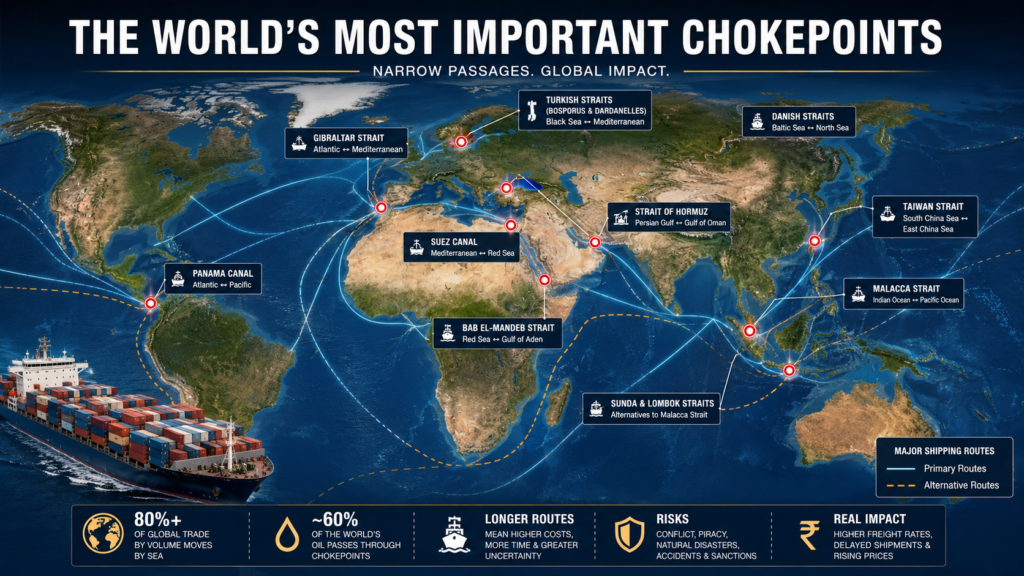
The Strait of Malacca connects the Indian Ocean with the Pacific. Hormuz connects the Persian Gulf with the Arabian Sea. Bab el-Mandeb connects the Red Sea with the Gulf of Aden. Suez provides a shortcut between the Mediterranean and the Red Sea.
There are alternatives to most of these routes.
That is important.
A chokepoint is not necessarily a place where trade stops completely if the passage closes. Rather, it is a place where the cheapest, fastest or most convenient route can disappear.
And that can be almost as consequential.
More than 80 per cent of global merchandise trade by volume travels by sea. That means shipping is not some peripheral part of the global economy. It is one of the systems on which the modern economy is built.
The world’s factories, refineries, mines, ports, supermarkets and consumers are therefore connected by routes that are ultimately constrained by geography.
The world’s two great oil chokepoints
If you look specifically at oil, two waterways stand out above the rest:
the Strait of Hormuz and the Strait of Malacca.
According to the US Energy Information Administration, around 20.9 million barrels a day of crude oil and petroleum products passed through Hormuz in the first half of 2025.
Malacca carried even more — around 23.2 million barrels a day.
Those figures help explain why a piece of geography can become a geopolitical obsession.
1. Strait of Hormuz: The world’s energy gate
Hormuz lies between Iran and Oman.
On one side is the Persian Gulf, home to some of the world’s biggest oil and gas producers. On the other is the Gulf of Oman and, beyond it, the Arabian Sea.
This makes Hormuz the exit door for a huge share of Gulf energy exports.
Saudi Arabia, Iraq, Kuwait, the UAE, Qatar and Iran all sit in or around this energy-rich region.
For countries in East Asia, the route is particularly important.
Japan, South Korea, China and India all depend heavily on energy arriving by sea.
And there is another complication: pipelines can bypass only part of the problem.
Saudi Arabia and the UAE have alternative pipeline routes that can move some oil without using Hormuz. But their combined capacity is nowhere near enough to replace all the volumes normally passing through the strait.
That is the essence of a chokepoint.
There may be an alternative.
There just isn’t enough of one.
Hormuz is also important for liquefied natural gas. Qatar is one of the world’s largest LNG exporters, and much of its LNG exports normally have to pass through the strait.
So Hormuz is not simply an oil story.
It is an energy-security story.
And that is why any serious disruption there can affect countries that are nowhere near the Middle East.
2. Strait of Malacca: Asia’s energy highway
Now move east.
Between the Malay Peninsula and the Indonesian island of Sumatra lies the Strait of Malacca.
It looks very different from Hormuz.
There are no enormous Gulf oil fields immediately beside it. Instead, Malacca is important because of where it sits.
It is the shortest major maritime route connecting the Indian Ocean with East Asia.
Ships carrying Middle Eastern oil towards China, Japan and South Korea can use Malacca to enter the South China Sea and continue into the Pacific.
This makes Malacca one of the most important maritime passages on Earth.
China is particularly dependent on it.
This has produced a phrase that has become familiar in discussions of Chinese strategy: the “Malacca dilemma”.
The basic problem is simple.
China imports huge quantities of energy and raw materials by sea. Much of that traffic travels through waters beyond China’s immediate control before reaching Chinese ports.
A serious disruption around Malacca could therefore threaten China’s energy supplies and trade.
But there is an important nuance.
Malacca is not the only route.
Ships can use the Sunda Strait or Lombok Strait, both in Indonesia.
They can also take longer routes.
The problem is that alternatives are less convenient, and in some cases less suitable for particular ships.
So again, the issue is not:
“Can ships get around it?”
They usually can.
The better question is:
“How much will getting around it cost?”
Suez: The shortcut that changed world trade
The Suez Canal is different because it is artificial.
It cuts through Egypt, connecting the Mediterranean Sea with the Red Sea.
Before the canal, ships travelling between Europe and Asia had to sail around Africa.
Suez transformed that journey.
A vessel travelling from Asia to Europe could now take a vastly shorter route.
That matters because distance is money in shipping.
A ship burns fuel. Its crew has to be paid. The vessel itself costs money to operate. Cargo has deadlines. Containers have to be available for the next shipment.
Every additional day at sea therefore has an economic cost.
The Suez Canal became one of the world’s great shortcuts.
But shortcuts create dependence.
That became painfully obvious when the container ship Ever Given blocked the canal in 2021.
The ship was eventually freed, but the incident provided a remarkably useful demonstration of what a chokepoint means.
A single vessel was enough to disrupt a waterway through which enormous quantities of global trade normally pass.
The lesson was not that the canal is fragile in a literal sense.
The lesson was that concentrated traffic creates concentrated risk.
Bab el-Mandeb: The gate before Suez
Look south from Suez and you reach the Red Sea.
At its southern end lies the Bab el-Mandeb Strait.
This is the gateway between the Red Sea and the Gulf of Aden.
If a ship is travelling from Asia to Europe through Suez, it generally has to pass through Bab el-Mandeb first.
That makes the two waterways part of the same strategic system.
And the events following attacks on commercial shipping in the Red Sea from late 2023 demonstrated the relationship vividly.
Rather than risk the Red Sea, many shipping companies diverted vessels around the southern tip of Africa.
Suddenly, a voyage that normally used Suez became much longer.
The alternative was not impossible.
It was expensive.
The Cape of Good Hope: Not a chokepoint, but the great escape route
The Cape of Good Hope deserves a place in this story even though it is not itself a chokepoint.
It is the alternative.
When ships cannot or do not want to use Suez and Bab el-Mandeb, they can sail around the southern tip of Africa.
But geography collects its fee.
A longer voyage requires more fuel and more time.
It also ties up ships for longer.
Imagine that a container ship normally completes a particular journey in 25 days.
Now imagine the route takes 35 days.
The ship has not become less capable.
But the global fleet has effectively lost part of its capacity.
That means shipping companies may need more vessels to carry the same annual volume.
Freight rates can rise.
Delivery times can stretch.
Ports can become congested.
And the effect can spread through supply chains.
Panama: The shortcut between two oceans
On the other side of the world is the Panama Canal.
It connects the Atlantic and Pacific oceans across Central America.
Its importance is especially obvious for ships travelling between the east and west coasts of the Americas.
Without Panama, many vessels have to take the much longer route around the southern tip of South America.
But Panama has another vulnerability that makes it an especially interesting chokepoint:
water.
The canal depends on freshwater to operate its locks.
Periods of drought can therefore reduce the number or size of vessels that can transit.
That is a useful reminder that chokepoints are not threatened only by war.
They can also be disrupted by:
- drought;
- storms;
- accidents;
- piracy;
- war;
- sanctions;
- political instability;
- infrastructure failure.
A chokepoint is ultimately a concentration of dependence.
The Turkish Straits: The Black Sea’s gateway
Now move towards Europe.
The Turkish Straits system consists primarily of the Bosporus and Dardanelles, linked by the Sea of Marmara.
The Bosporus separates Europe and Asia and runs through Istanbul.
The Dardanelles connects the Sea of Marmara with the Aegean Sea.
Together, they provide the maritime gateway between the Black Sea and the Mediterranean.
That makes them particularly important for countries such as Russia, Ukraine, Romania and Bulgaria.
The geography also has enormous strategic significance because the Black Sea is effectively a semi-enclosed maritime space.
Ships leaving it have to pass through the Turkish Straits.
This is one reason Turkey’s geographic position has mattered for centuries.
The straits are simultaneously:
a commercial route, a military route and a geopolitical lever.
The Danish Straits: Northern Europe’s narrow gateway
Further north are the Danish Straits.
They connect the Baltic Sea with the North Sea and the wider Atlantic.
Their importance is particularly pronounced for maritime trade involving the Baltic region.
The geography matters because the Baltic is another semi-enclosed sea.
Ships entering or leaving it have limited routes.
The Danish Straits therefore form a natural gateway for trade involving ports in countries such as Denmark, Sweden, Finland, Germany, Poland and the Baltic states.
They are not as famous in popular discussions as Hormuz or Suez.
But strategic importance does not always come with global headlines.
Sometimes it comes from geography.
Gibraltar: The western entrance to the Mediterranean
At the other end of the Mediterranean is another famous passage: the Strait of Gibraltar.
It separates Spain from Morocco and connects the Mediterranean with the Atlantic Ocean.
For ships travelling between the Atlantic and the Mediterranean, there is no comparable shortcut.
Gibraltar also illustrates something important about chokepoints.
A waterway does not have to carry the world’s largest quantity of oil to be strategically important.
Its value can come from its position in a broader network.
Mediterranean ports, the Suez Canal, North African energy exports and European trade routes all connect through this maritime gateway.
And sitting beside the strait is Gibraltar itself — a British Overseas Territory whose strategic importance has been recognised for centuries.
Taiwan Strait: When a trade route becomes a geopolitical fault line
There is another waterway that deserves special treatment.
The Taiwan Strait.
It lies between Taiwan and mainland China and connects the South China Sea with the East China Sea.
Unlike Suez or Panama, its importance does not come from a canal.
Unlike Hormuz, its primary significance is not simply oil.
It is important because it sits in the middle of one of the world’s most concentrated manufacturing and trading regions.
Research by the Center for Strategic and International Studies estimates that around $2.45 trillion worth of goods — more than one-fifth of global maritime trade — passed through the Taiwan Strait in 2022.
That includes enormous flows involving China, Taiwan, Japan and South Korea.
The strait therefore carries not only energy and raw materials but also manufactured goods, machinery and components.
And then there is Taiwan’s semiconductor industry.
This makes the Taiwan Strait unusually important.
A disruption there would not simply mean ships taking a longer route.
It could simultaneously affect:
shipping + energy + manufacturing + semiconductors + China + Taiwan + Japan + South Korea + the United States.
That is why the Taiwan Strait is one of the world’s most consequential potential maritime flashpoints.
So who ‘controls’ a chokepoint?
This question sounds simpler than it is.
A country may sit beside a chokepoint without legally owning the waterway.
International maritime law, territorial waters, navigational rights and treaties all matter.
Some waterways are international routes. Some contain territorial waters. Canals operate under specific legal and administrative regimes.
And military power is another matter altogether.
A country may not legally “own” a passage but may have enormous capacity to influence what happens there.
Iran’s location beside Hormuz is the obvious example.
Indonesia’s geography gives it enormous significance around Malacca, Sunda and Lombok.
Egypt administers the Suez Canal.
Panama operates the Panama Canal.
Turkey controls the shores of the Bosporus and Dardanelles.
But strategic control is rarely absolute.
A chokepoint is a system involving geography, law, infrastructure, shipping companies, navies, ports, insurance markets and alternative routes.
That is why the idea of a single country simply “controlling world trade” is usually too simplistic.
What actually happens when a chokepoint is disrupted?
This is where the subject becomes relevant to everyday life.
Suppose a major route becomes unavailable.
The first reaction may be obvious.
Ships reroute.
But then the second-order effects begin.
1. The journey becomes longer
A ship that once travelled 8,000 kilometres may suddenly have to travel 10,000 or 12,000.
That means more time at sea.
2. Fuel costs rise
Ships consume fuel.
Longer journeys mean greater fuel consumption.
3. More ships are required
If every ship spends more time completing a voyage, fewer ships are available to start new voyages.
The effective capacity of the global fleet falls.
4. Insurance becomes more expensive
Dangerous waters mean greater risk.
Insurers price that risk.
War-risk premiums can rise dramatically when vessels approach conflict zones.
5. Freight rates rise
Shipping companies pass higher operating and risk costs into freight prices.
6. Ports and supply chains adjust
A rerouted ship may arrive later than expected.
That can disrupt port schedules, container availability and factory inventories.
7. Prices can eventually rise
Not every disruption produces inflation.
But when the disrupted commodity is oil, gas or another essential input — or when the disruption affects a huge volume of manufactured goods — the economic effects can become widespread.
This is why the distance between a chokepoint and a consumer can be measured not only in kilometres.
It can be measured in prices.
And what does all this mean for India?
Quite a lot.
India sits in an unusually important geographical position.
The country faces the Indian Ocean and lies close to several of the world’s major maritime routes.
That is both an economic advantage and a strategic responsibility.
Start with oil.
India imports most of the crude oil it consumes.
Much of the country’s energy supply therefore arrives by sea.
Hormuz matters because Gulf producers are major energy suppliers to India.
Malacca matters because it is central to the wider Asian maritime network and connects the Indian Ocean with East Asia.
And the Andaman and Nicobar Islands sit close to the western entrance of the Malacca Strait.
That geography gives India something many countries do not have: a position near one of the world’s most important maritime gateways.
But geography alone does not equal control.
The strait is primarily within the maritime jurisdictions of Indonesia, Malaysia and Singapore, and commercial shipping follows international rules.
India’s advantage is therefore better understood as strategic proximity.
The Indian Navy’s ability to operate across the Indian Ocean gives India a role in maintaining maritime security and monitoring developments along important sea lanes.
This is one reason the Indian Ocean has become central to India’s broader strategic thinking.
The same geography that makes India vulnerable to disruptions also gives it influence.
The bigger lesson: Globalisation created efficiency — and vulnerability
For decades, globalisation encouraged companies to make supply chains efficient.
Factories specialised.
Ships became larger.
Ports became more sophisticated.
Companies reduced inventories.
Manufacturing spread across countries.
Goods travelled thousands of kilometres because doing so was economically rational.
The system worked remarkably well.
But efficiency has a price.
When there are many alternative suppliers, routes and inventories, a disruption can be absorbed.
When the system becomes highly concentrated, a disruption in one place can have disproportionate consequences.
That is the chokepoint problem.
The global economy has effectively built a gigantic network whose major arteries pass through a handful of narrow geographical spaces.
The result is extraordinary efficiency.
It is also extraordinary interdependence.
The ten places worth remembering
If you remember only a handful of names, remember these:
- Hormuz — the energy gateway out of the Persian Gulf.
- Malacca — the principal maritime bridge between the Indian Ocean and East Asia.
- Suez — the artificial shortcut between Europe and Asia.
- Bab el-Mandeb — the southern gateway to the Red Sea and Suez.
- Panama — the shortcut between the Atlantic and Pacific.
- Turkish Straits — the Black Sea’s gateway to the Mediterranean.
- Danish Straits — the Baltic’s maritime gateway.
- Gibraltar — the entrance to the Mediterranean from the Atlantic.
- Taiwan Strait — a critical trade corridor at the heart of East Asian geopolitics.
- Sunda and Lombok — important alternatives to Malacca.
And then remember the great fallback route: the Cape of Good Hope.
It is not a chokepoint.
It is what happens when the chokepoint becomes too risky.
The question is not whether ships can go around
This is perhaps the most important thing to understand.
When you hear that a waterway is “closed”, it is tempting to imagine world trade coming to a halt.
That is rarely what happens.
Ships can often take another route.
The problem is that geography has already chosen the efficient route for them.
The alternative may be longer.
It may be more expensive.
It may require more ships.
It may pass through other dangerous waters.
It may create congestion somewhere else.
And those costs accumulate.
A chokepoint therefore does something more subtle than simply stopping trade.
It changes the economics of trade.
That is why a narrow strip of water can matter to a factory in China, an oil refinery in India, a supermarket in Britain, a car manufacturer in Germany or a consumer buying a product thousands of kilometres from the sea.
The modern world may feel digital and borderless.
But underneath the cloud computing, instant payments and global supply chains is something much older:
ships moving across oceans.
And those ships still have to follow geography.
That is why the world’s chokepoints matter.